|
|
|||||||||||||||||
| Point ID: 295 | Downloads | Plots | Site Data | Code: 05BJ005 |
|
|
|||||||||||||||||
| Download | |
|---|---|
| Site Descriptor Information | Site Time Series Data |
| Link to all available data | |
| View: | Time Series | All |
| Units: | mm |
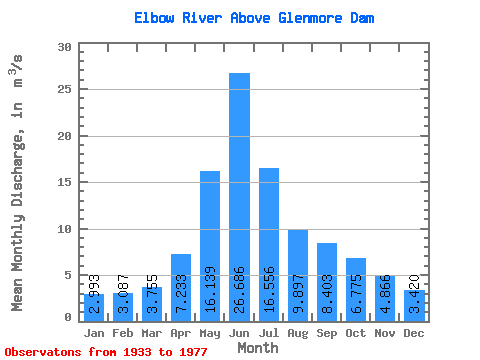
| Statistic | Jan | Feb | Mar | Apr | May | Jun | Jul | Aug | Sep | Oct | Nov | Dec | Annual |
|---|---|---|---|---|---|---|---|---|---|---|---|---|---|
| Mean | 2.99 | 3.09 | 3.75 | 7.23 | 16.14 | 26.69 | 16.56 | 9.90 | 8.40 | 6.78 | 4.87 | 3.42 | 9.19 |
| Standard Deviation | 0.65 | 0.67 | 1.20 | 3.95 | 8.20 | 11.22 | 8.80 | 4.88 | 5.44 | 3.21 | 1.67 | 0.91 | 3.06 |
| Min | 1.97 | 1.80 | 2.22 | 3.24 | 4.47 | 8.55 | 4.18 | 3.82 | 3.68 | 3.25 | 2.88 | 1.77 | 4.26 |
| Max | 5.09 | 5.03 | 8.03 | 23.50 | 44.30 | 64.10 | 43.10 | 26.30 | 35.70 | 19.90 | 12.10 | 5.85 | 19.06 |
| Coefficient of Variation | 0.22 | 0.22 | 0.32 | 0.55 | 0.51 | 0.42 | 0.53 | 0.49 | 0.65 | 0.47 | 0.34 | 0.27 | 0.33 |
 Return to R-Arctic Net Home Page