|
|
|||||||||||||||||
| Point ID: 295 | Downloads | Plots | Site Data | Code: 05BJ005 |
|
|
|||||||||||||||||
| Download | |
|---|---|
| Site Descriptor Information | Site Time Series Data |
| Link to all available data | |
| View: | Time Series | All |
| Units: | m3/s |
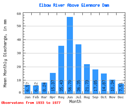
| Statistic | Jan | Feb | Mar | Apr | May | Jun | Jul | Aug | Sep | Oct | Nov | Dec | Annual |
|---|---|---|---|---|---|---|---|---|---|---|---|---|---|
| Mean | 6.57 | 6.17 | 8.24 | 15.37 | 35.43 | 56.70 | 36.34 | 21.72 | 17.85 | 14.87 | 10.34 | 7.51 | 237.77 |
| Standard Deviation | 1.43 | 1.34 | 2.63 | 8.39 | 17.99 | 23.83 | 19.32 | 10.70 | 11.55 | 7.04 | 3.55 | 2.00 | 79.19 |
| Min | 4.32 | 3.60 | 4.87 | 6.88 | 9.81 | 18.16 | 9.18 | 8.38 | 7.82 | 7.13 | 6.12 | 3.88 | 110.18 |
| Max | 11.17 | 10.06 | 17.63 | 49.93 | 97.24 | 136.19 | 94.61 | 57.73 | 75.85 | 43.68 | 25.71 | 12.84 | 493.06 |
| Coefficient of Variation | 0.22 | 0.22 | 0.32 | 0.55 | 0.51 | 0.42 | 0.53 | 0.49 | 0.65 | 0.47 | 0.34 | 0.27 | 0.33 |
 Return to R-Arctic Net Home Page