|
|
|||||||||||||||||
| Point ID: 294 | Downloads | Plots | Site Data | Code: 05BJ004 |
|
|
|||||||||||||||||
| Download | |
|---|---|
| Site Descriptor Information | Site Time Series Data |
| Link to all available data | |
| View: | Time Series | All |
| Units: | mm |
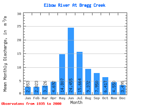
| Statistic | Jan | Feb | Mar | Apr | May | Jun | Jul | Aug | Sep | Oct | Nov | Dec | Annual |
|---|---|---|---|---|---|---|---|---|---|---|---|---|---|
| Mean | 2.85 | 2.82 | 3.23 | 4.69 | 14.81 | 24.45 | 15.66 | 9.37 | 7.95 | 6.42 | 4.55 | 3.50 | 7.82 |
| Standard Deviation | 0.58 | 0.48 | 0.77 | 1.30 | 7.33 | 11.15 | 7.94 | 3.64 | 3.87 | 2.10 | 0.92 | 0.81 | 2.14 |
| Min | 1.89 | 2.01 | 1.63 | 3.04 | 4.52 | 5.81 | 2.32 | 3.48 | 4.52 | 3.92 | 3.14 | 2.36 | 4.86 |
| Max | 4.52 | 4.07 | 6.32 | 9.34 | 39.80 | 62.50 | 41.30 | 22.50 | 29.50 | 14.20 | 7.00 | 6.23 | 12.87 |
| Coefficient of Variation | 0.20 | 0.17 | 0.24 | 0.28 | 0.49 | 0.46 | 0.51 | 0.39 | 0.49 | 0.33 | 0.20 | 0.23 | 0.27 |
 Return to R-Arctic Net Home Page