|
|
|||||||||||||||||
| Point ID: 294 | Downloads | Plots | Site Data | Code: 05BJ004 |
|
|
|||||||||||||||||
| Download | |
|---|---|
| Site Descriptor Information | Site Time Series Data |
| Link to all available data | |
| View: | Time Series | All |
| Units: | m3/s |
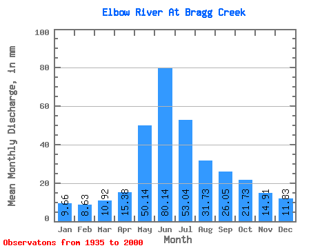
| Statistic | Jan | Feb | Mar | Apr | May | Jun | Jul | Aug | Sep | Oct | Nov | Dec | Annual |
|---|---|---|---|---|---|---|---|---|---|---|---|---|---|
| Mean | 9.66 | 8.71 | 10.92 | 15.38 | 50.13 | 80.14 | 53.03 | 31.73 | 26.05 | 21.73 | 14.91 | 11.83 | 311.99 |
| Standard Deviation | 1.98 | 1.48 | 2.61 | 4.27 | 24.81 | 36.54 | 26.89 | 12.32 | 12.67 | 7.12 | 3.03 | 2.75 | 85.31 |
| Min | 6.40 | 6.20 | 5.52 | 9.96 | 15.30 | 19.04 | 7.86 | 11.78 | 14.81 | 13.27 | 10.29 | 7.99 | 193.97 |
| Max | 15.30 | 12.55 | 21.40 | 30.61 | 134.75 | 204.80 | 139.82 | 76.18 | 96.67 | 48.08 | 22.94 | 21.09 | 513.50 |
| Coefficient of Variation | 0.20 | 0.17 | 0.24 | 0.28 | 0.49 | 0.46 | 0.51 | 0.39 | 0.49 | 0.33 | 0.20 | 0.23 | 0.27 |
 Return to R-Arctic Net Home Page