|
|
|||||||||||||||||
| Point ID: 2939 | Downloads | Plots | Site Data | Code: 05NG003 |
|
|
|||||||||||||||||
| Download | |
|---|---|
| Site Descriptor Information | Site Time Series Data |
| Link to all available data | |
| View: | Time Series | All |
| Units: | mm |
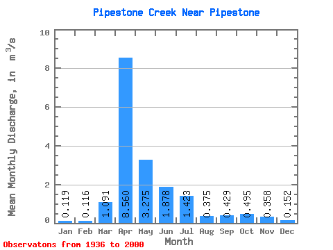
| Statistic | Jan | Feb | Mar | Apr | May | Jun | Jul | Aug | Sep | Oct | Nov | Dec | Annual |
|---|---|---|---|---|---|---|---|---|---|---|---|---|---|
| Mean | 0.12 | 0.12 | 1.09 | 8.56 | 3.27 | 1.88 | 1.42 | 0.38 | 0.43 | 0.49 | 0.36 | 0.15 | 1.09 |
| Standard Deviation | 0.20 | 0.21 | 1.67 | 10.54 | 5.06 | 3.48 | 3.37 | 0.60 | 0.81 | 0.82 | 0.55 | 0.21 | 1.41 |
| Min | 0.00 | 0.00 | 0.00 | 0.20 | 0.01 | 0.00 | 0.00 | 0.00 | 0.00 | 0.00 | 0.00 | 0.00 | 0.03 |
| Max | 1.02 | 1.02 | 5.91 | 66.10 | 30.80 | 16.50 | 24.00 | 3.32 | 4.59 | 4.63 | 2.71 | 1.06 | 7.87 |
| Coefficient of Variation | 1.66 | 1.80 | 1.53 | 1.23 | 1.55 | 1.85 | 2.37 | 1.61 | 1.88 | 1.66 | 1.53 | 1.41 | 1.29 |
 Return to R-Arctic Net Home Page