|
|
|||||||||||||||||
| Point ID: 2939 | Downloads | Plots | Site Data | Code: 05NG003 |
|
|
|||||||||||||||||
| Download | |
|---|---|
| Site Descriptor Information | Site Time Series Data |
| Link to all available data | |
| View: | Time Series | All |
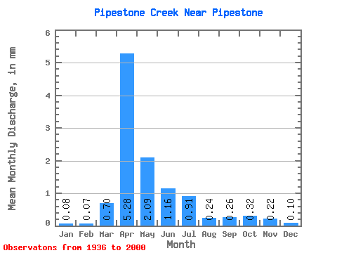
| Units: | m3/s |
| Statistic | Jan | Feb | Mar | Apr | May | Jun | Jul | Aug | Sep | Oct | Nov | Dec | Annual |
|---|---|---|---|---|---|---|---|---|---|---|---|---|---|
| Mean | 0.08 | 0.07 | 0.70 | 5.28 | 2.09 | 1.16 | 0.91 | 0.24 | 0.27 | 0.32 | 0.22 | 0.10 | 8.22 |
| Standard Deviation | 0.13 | 0.12 | 1.06 | 6.50 | 3.23 | 2.15 | 2.15 | 0.39 | 0.50 | 0.52 | 0.34 | 0.14 | 10.63 |
| Min | 0.00 | 0.00 | 0.00 | 0.12 | 0.01 | 0.00 | 0.00 | 0.00 | 0.00 | 0.00 | 0.00 | 0.00 | 0.23 |
| Max | 0.65 | 0.59 | 3.77 | 40.79 | 19.64 | 10.18 | 15.30 | 2.12 | 2.83 | 2.95 | 1.67 | 0.68 | 59.14 |
| Coefficient of Variation | 1.66 | 1.80 | 1.53 | 1.23 | 1.55 | 1.85 | 2.37 | 1.61 | 1.88 | 1.66 | 1.53 | 1.41 | 1.29 |
 Return to R-Arctic Net Home Page