|
|
|||||||||||||||||
| Point ID: 2920 | Downloads | Plots | Site Data | Code: 05MJ004 |
|
|
|||||||||||||||||
| Download | |
|---|---|
| Site Descriptor Information | Site Time Series Data |
| Link to all available data | |
| View: | Time Series | All |
| Units: | mm |
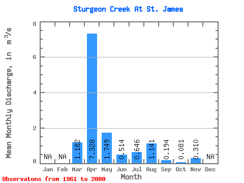
| Statistic | Jan | Feb | Mar | Apr | May | Jun | Jul | Aug | Sep | Oct | Nov | Dec | Annual |
|---|---|---|---|---|---|---|---|---|---|---|---|---|---|
| Mean | 1.18 | 7.33 | 1.75 | 0.51 | 0.65 | 1.14 | 0.19 | 0.08 | 0.31 | ||||
| Standard Deviation | 2.74 | 6.30 | 3.06 | 0.93 | 1.59 | 3.19 | 0.39 | 0.08 | |||||
| Min | 0.00 | 0.22 | 0.01 | 0.01 | 0.00 | 0.00 | 0.01 | 0.02 | 0.31 | ||||
| Max | 13.20 | 22.50 | 11.20 | 4.36 | 6.70 | 15.80 | 1.78 | 0.39 | 0.31 | ||||
| Coefficient of Variation | 2.32 | 0.86 | 1.75 | 1.80 | 2.46 | 2.80 | 2.00 | 1.04 |
 Return to R-Arctic Net Home Page