|
|
|||||||||||||||||
| Point ID: 2920 | Downloads | Plots | Site Data | Code: 05MJ004 |
|
|
|||||||||||||||||
| Download | |
|---|---|
| Site Descriptor Information | Site Time Series Data |
| Link to all available data | |
| View: | Time Series | All |
| Units: | m3/s |
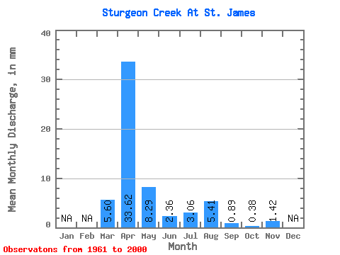
| Statistic | Jan | Feb | Mar | Apr | May | Jun | Jul | Aug | Sep | Oct | Nov | Dec | Annual |
|---|---|---|---|---|---|---|---|---|---|---|---|---|---|
| Mean | 5.60 | 33.62 | 8.29 | 2.36 | 3.06 | 5.41 | 0.89 | 0.39 | 1.42 | ||||
| Standard Deviation | 12.98 | 28.91 | 14.51 | 4.25 | 7.54 | 15.13 | 1.78 | 0.40 | |||||
| Min | 0.00 | 1.02 | 0.05 | 0.06 | 0.02 | 0.01 | 0.03 | 0.09 | 1.42 | ||||
| Max | 62.57 | 103.22 | 53.09 | 20.00 | 31.76 | 74.89 | 8.17 | 1.84 | 1.42 | ||||
| Coefficient of Variation | 2.32 | 0.86 | 1.75 | 1.80 | 2.46 | 2.80 | 2.00 | 1.04 |
 Return to R-Arctic Net Home Page