|
|
|||||||||||||||||
| Point ID: 2914 | Downloads | Plots | Site Data | Code: 05MH008 |
|
|
|||||||||||||||||
| Download | |
|---|---|
| Site Descriptor Information | Site Time Series Data |
| Link to all available data | |
| View: | Time Series | All |
| Units: | mm |
| Statistic | Jan | Feb | Mar | Apr | May | Jun | Jul | Aug | Sep | Oct | Nov | Dec | Annual |
|---|---|---|---|---|---|---|---|---|---|---|---|---|---|
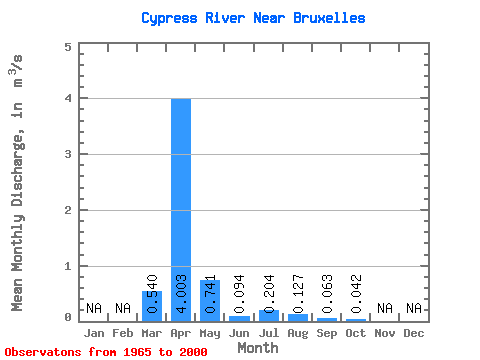
| Mean | 0.54 | 4.00 | 0.74 | 0.09 | 0.20 | 0.13 | 0.06 | 0.04 | |||||
| Standard Deviation | 0.94 | 3.68 | 1.11 | 0.10 | 0.42 | 0.37 | 0.19 | 0.09 | |||||
| Min | 0.00 | 0.02 | 0.04 | 0.00 | 0.00 | 0.00 | 0.00 | 0.00 | |||||
| Max | 3.81 | 12.20 | 5.25 | 0.39 | 2.26 | 1.73 | 1.04 | 0.51 | |||||
| Coefficient of Variation | 1.75 | 0.92 | 1.49 | 1.06 | 2.05 | 2.94 | 2.92 | 2.10 |
 Return to R-Arctic Net Home Page