|
|
|||||||||||||||||
| Point ID: 2914 | Downloads | Plots | Site Data | Code: 05MH008 |
|
|
|||||||||||||||||
| Download | |
|---|---|
| Site Descriptor Information | Site Time Series Data |
| Link to all available data | |
| View: | Time Series | All |
| Units: | m3/s |
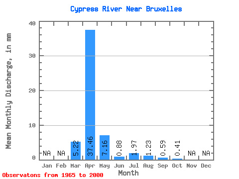
| Statistic | Jan | Feb | Mar | Apr | May | Jun | Jul | Aug | Sep | Oct | Nov | Dec | Annual |
|---|---|---|---|---|---|---|---|---|---|---|---|---|---|
| Mean | 5.22 | 37.46 | 7.16 | 0.88 | 1.97 | 1.23 | 0.59 | 0.41 | |||||
| Standard Deviation | 9.13 | 34.47 | 10.70 | 0.94 | 4.04 | 3.61 | 1.74 | 0.86 | |||||
| Min | 0.00 | 0.21 | 0.37 | 0.00 | 0.00 | 0.00 | 0.00 | 0.00 | |||||
| Max | 36.84 | 114.16 | 50.76 | 3.68 | 21.85 | 16.73 | 9.73 | 4.91 | |||||
| Coefficient of Variation | 1.75 | 0.92 | 1.49 | 1.06 | 2.05 | 2.94 | 2.92 | 2.10 |
 Return to R-Arctic Net Home Page