|
|
|||||||||||||||||
| Point ID: 2910 | Downloads | Plots | Site Data | Code: 05MH004 |
|
|
|||||||||||||||||
| Download | |
|---|---|
| Site Descriptor Information | Site Time Series Data |
| Link to all available data | |
| View: | Time Series | All |
| Units: | mm |
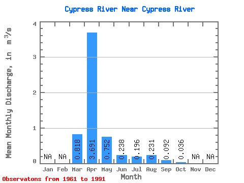
| Statistic | Jan | Feb | Mar | Apr | May | Jun | Jul | Aug | Sep | Oct | Nov | Dec | Annual |
|---|---|---|---|---|---|---|---|---|---|---|---|---|---|
| Mean | 0.82 | 3.69 | 0.75 | 0.24 | 0.20 | 0.23 | 0.09 | 0.04 | |||||
| Standard Deviation | 1.37 | 3.62 | 1.15 | 0.30 | 0.32 | 0.66 | 0.22 | 0.05 | |||||
| Min | 0.00 | 0.12 | 0.07 | 0.01 | 0.00 | 0.00 | 0.00 | 0.00 | |||||
| Max | 4.51 | 13.50 | 4.89 | 1.22 | 1.19 | 3.01 | 0.87 | 0.19 | |||||
| Coefficient of Variation | 1.68 | 0.98 | 1.53 | 1.25 | 1.61 | 2.85 | 2.41 | 1.39 |
 Return to R-Arctic Net Home Page