|
|
|||||||||||||||||
| Point ID: 2910 | Downloads | Plots | Site Data | Code: 05MH004 |
|
|
|||||||||||||||||
| Download | |
|---|---|
| Site Descriptor Information | Site Time Series Data |
| Link to all available data | |
| View: | Time Series | All |
| Units: | m3/s |
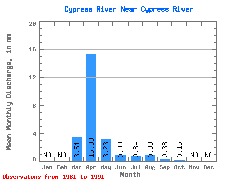
| Statistic | Jan | Feb | Mar | Apr | May | Jun | Jul | Aug | Sep | Oct | Nov | Dec | Annual |
|---|---|---|---|---|---|---|---|---|---|---|---|---|---|
| Mean | 3.51 | 15.33 | 3.23 | 0.99 | 0.84 | 0.99 | 0.38 | 0.15 | |||||
| Standard Deviation | 5.89 | 15.02 | 4.95 | 1.23 | 1.36 | 2.83 | 0.92 | 0.22 | |||||
| Min | 0.00 | 0.49 | 0.29 | 0.03 | 0.00 | 0.00 | 0.00 | 0.00 | |||||
| Max | 19.36 | 56.08 | 20.99 | 5.07 | 5.11 | 12.92 | 3.60 | 0.81 | |||||
| Coefficient of Variation | 1.68 | 0.98 | 1.53 | 1.25 | 1.61 | 2.85 | 2.41 | 1.39 |
 Return to R-Arctic Net Home Page