|
|
|||||||||||||||||
| Point ID: 2883 | Downloads | Plots | Site Data | Code: 05ME006 |
|
|
|||||||||||||||||
| Download | |
|---|---|
| Site Descriptor Information | Site Time Series Data |
| Link to all available data | |
| View: | Time Series | All |
| Units: | mm |
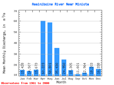
| Statistic | Jan | Feb | Mar | Apr | May | Jun | Jul | Aug | Sep | Oct | Nov | Dec | Annual |
|---|---|---|---|---|---|---|---|---|---|---|---|---|---|
| Mean | 15.43 | 14.51 | 15.67 | 60.22 | 58.80 | 35.43 | 24.95 | 15.30 | 11.60 | 12.96 | 18.20 | 16.34 | 27.05 |
| Standard Deviation | 6.29 | 5.89 | 10.97 | 50.45 | 65.28 | 33.79 | 23.45 | 14.56 | 10.24 | 8.36 | 6.92 | 6.66 | 19.33 |
| Min | 6.11 | 5.63 | 1.75 | 7.95 | 3.75 | 3.03 | 1.36 | 0.50 | 0.85 | 1.87 | 5.91 | 5.37 | 6.66 |
| Max | 30.90 | 30.00 | 44.80 | 232.00 | 344.00 | 135.00 | 80.70 | 47.00 | 36.80 | 33.80 | 34.90 | 32.00 | 72.66 |
| Coefficient of Variation | 0.41 | 0.41 | 0.70 | 0.84 | 1.11 | 0.95 | 0.94 | 0.95 | 0.88 | 0.65 | 0.38 | 0.41 | 0.71 |
 Return to R-Arctic Net Home Page