|
|
|||||||||||||||||
| Point ID: 2883 | Downloads | Plots | Site Data | Code: 05ME006 |
|
|
|||||||||||||||||
| Download | |
|---|---|
| Site Descriptor Information | Site Time Series Data |
| Link to all available data | |
| View: | Time Series | All |
| Units: | m3/s |
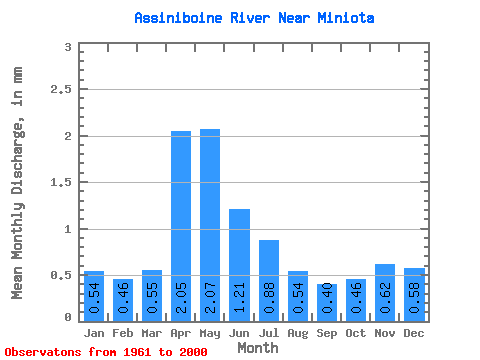
| Statistic | Jan | Feb | Mar | Apr | May | Jun | Jul | Aug | Sep | Oct | Nov | Dec | Annual |
|---|---|---|---|---|---|---|---|---|---|---|---|---|---|
| Mean | 0.54 | 0.47 | 0.55 | 2.05 | 2.07 | 1.21 | 0.88 | 0.54 | 0.40 | 0.46 | 0.62 | 0.57 | 11.22 |
| Standard Deviation | 0.22 | 0.19 | 0.39 | 1.72 | 2.30 | 1.15 | 0.82 | 0.51 | 0.35 | 0.29 | 0.24 | 0.23 | 8.02 |
| Min | 0.21 | 0.18 | 0.06 | 0.27 | 0.13 | 0.10 | 0.05 | 0.02 | 0.03 | 0.07 | 0.20 | 0.19 | 2.76 |
| Max | 1.09 | 0.96 | 1.58 | 7.90 | 12.11 | 4.60 | 2.84 | 1.65 | 1.25 | 1.19 | 1.19 | 1.13 | 30.13 |
| Coefficient of Variation | 0.41 | 0.41 | 0.70 | 0.84 | 1.11 | 0.95 | 0.94 | 0.95 | 0.88 | 0.65 | 0.38 | 0.41 | 0.71 |
 Return to R-Arctic Net Home Page