|
|
|||||||||||||||||
| Point ID: 2857 | Downloads | Plots | Site Data | Code: 05LL011 |
|
|
|||||||||||||||||
| Download | |
|---|---|
| Site Descriptor Information | Site Time Series Data |
| Link to all available data | |
| View: | Time Series | All |
| Units: | mm |
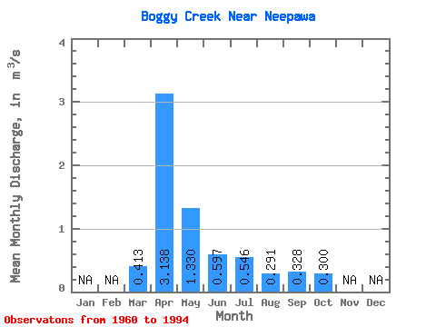
| Statistic | Jan | Feb | Mar | Apr | May | Jun | Jul | Aug | Sep | Oct | Nov | Dec | Annual |
|---|---|---|---|---|---|---|---|---|---|---|---|---|---|
| Mean | 0.41 | 3.14 | 1.33 | 0.60 | 0.55 | 0.29 | 0.33 | 0.30 | |||||
| Standard Deviation | 0.33 | 3.10 | 1.63 | 0.65 | 0.78 | 0.22 | 0.29 | 0.20 | |||||
| Min | 0.13 | 0.23 | 0.15 | 0.17 | 0.14 | 0.04 | 0.07 | 0.13 | |||||
| Max | 1.84 | 10.20 | 7.94 | 3.67 | 3.86 | 1.02 | 1.22 | 1.04 | |||||
| Coefficient of Variation | 0.80 | 0.99 | 1.23 | 1.08 | 1.43 | 0.77 | 0.89 | 0.65 |
 Return to R-Arctic Net Home Page