|
|
|||||||||||||||||
| Point ID: 2857 | Downloads | Plots | Site Data | Code: 05LL011 |
|
|
|||||||||||||||||
| Download | |
|---|---|
| Site Descriptor Information | Site Time Series Data |
| Link to all available data | |
| View: | Time Series | All |
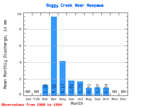
| Units: | m3/s |
| Statistic | Jan | Feb | Mar | Apr | May | Jun | Jul | Aug | Sep | Oct | Nov | Dec | Annual |
|---|---|---|---|---|---|---|---|---|---|---|---|---|---|
| Mean | 1.29 | 9.52 | 4.17 | 1.81 | 1.71 | 0.91 | 1.00 | 0.94 | |||||
| Standard Deviation | 1.04 | 9.40 | 5.12 | 1.96 | 2.45 | 0.70 | 0.89 | 0.61 | |||||
| Min | 0.41 | 0.70 | 0.48 | 0.51 | 0.42 | 0.12 | 0.20 | 0.41 | |||||
| Max | 5.77 | 30.96 | 24.90 | 11.14 | 12.10 | 3.20 | 3.70 | 3.26 | |||||
| Coefficient of Variation | 0.80 | 0.99 | 1.23 | 1.08 | 1.43 | 0.77 | 0.89 | 0.65 |
 Return to R-Arctic Net Home Page