|
|
|||||||||||||||||
| Point ID: 2835 | Downloads | Plots | Site Data | Code: 05LJ026 |
|
|
|||||||||||||||||
| Download | |
|---|---|
| Site Descriptor Information | Site Time Series Data |
| Link to all available data | |
| View: | Time Series | All |
| Units: | mm |
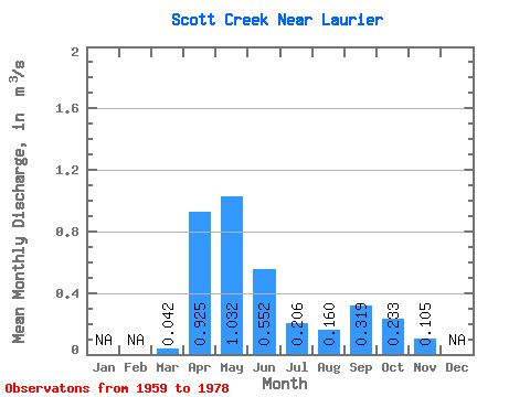
| Statistic | Jan | Feb | Mar | Apr | May | Jun | Jul | Aug | Sep | Oct | Nov | Dec | Annual |
|---|---|---|---|---|---|---|---|---|---|---|---|---|---|
| Mean | 0.04 | 0.93 | 1.03 | 0.55 | 0.21 | 0.16 | 0.32 | 0.23 | 0.10 | ||||
| Standard Deviation | 0.07 | 0.63 | 0.75 | 0.50 | 0.18 | 0.19 | 0.64 | 0.22 | |||||
| Min | 0.00 | 0.21 | 0.32 | 0.10 | 0.04 | 0.00 | 0.04 | 0.05 | 0.10 | ||||
| Max | 0.28 | 2.90 | 3.15 | 2.16 | 0.80 | 0.88 | 2.74 | 0.91 | 0.10 | ||||
| Coefficient of Variation | 1.67 | 0.68 | 0.73 | 0.90 | 0.86 | 1.21 | 2.01 | 0.94 |
 Return to R-Arctic Net Home Page