|
|
|||||||||||||||||
| Point ID: 2835 | Downloads | Plots | Site Data | Code: 05LJ026 |
|
|
|||||||||||||||||
| Download | |
|---|---|
| Site Descriptor Information | Site Time Series Data |
| Link to all available data | |
| View: | Time Series | All |
| Units: | m3/s |
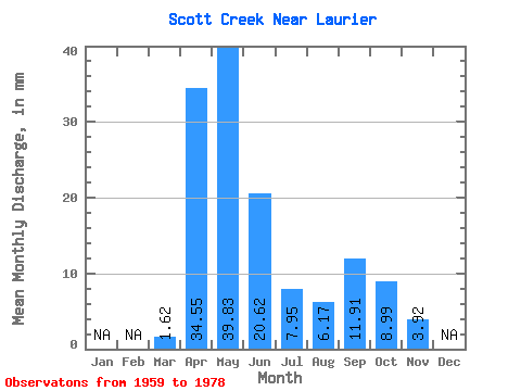
| Statistic | Jan | Feb | Mar | Apr | May | Jun | Jul | Aug | Sep | Oct | Nov | Dec | Annual |
|---|---|---|---|---|---|---|---|---|---|---|---|---|---|
| Mean | 1.63 | 34.54 | 39.83 | 20.60 | 7.96 | 6.19 | 11.93 | 8.99 | 3.92 | ||||
| Standard Deviation | 2.72 | 23.60 | 28.90 | 18.58 | 6.87 | 7.48 | 23.95 | 8.45 | |||||
| Min | 0.00 | 7.92 | 12.39 | 3.92 | 1.70 | 0.04 | 1.53 | 1.85 | 3.92 | ||||
| Max | 10.92 | 108.31 | 121.55 | 80.67 | 30.72 | 33.88 | 102.33 | 35.08 | 3.92 | ||||
| Coefficient of Variation | 1.67 | 0.68 | 0.73 | 0.90 | 0.86 | 1.21 | 2.01 | 0.94 |
 Return to R-Arctic Net Home Page