|
|
|||||||||||||||||
| Point ID: 283 | Downloads | Plots | Site Data | Code: 05BH004 |
|
|
|||||||||||||||||
| Download | |
|---|---|
| Site Descriptor Information | Site Time Series Data |
| Link to all available data | |
| View: | Time Series | All |
| Units: | mm |
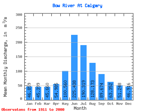
| Statistic | Jan | Feb | Mar | Apr | May | Jun | Jul | Aug | Sep | Oct | Nov | Dec | Annual |
|---|---|---|---|---|---|---|---|---|---|---|---|---|---|
| Mean | 46.86 | 45.40 | 45.66 | 54.98 | 100.56 | 225.44 | 190.32 | 128.17 | 89.67 | 63.35 | 51.25 | 46.92 | 90.51 |
| Standard Deviation | 14.93 | 15.14 | 14.49 | 16.54 | 32.04 | 77.00 | 67.51 | 36.83 | 24.35 | 15.03 | 11.32 | 14.31 | 16.21 |
| Min | 20.60 | 19.60 | 18.90 | 29.30 | 43.60 | 112.00 | 89.10 | 81.90 | 58.50 | 27.40 | 30.40 | 21.90 | 58.30 |
| Max | 78.30 | 79.00 | 81.90 | 107.00 | 207.00 | 472.00 | 437.00 | 237.00 | 192.00 | 106.00 | 81.70 | 80.50 | 146.49 |
| Coefficient of Variation | 0.32 | 0.33 | 0.32 | 0.30 | 0.32 | 0.34 | 0.35 | 0.29 | 0.27 | 0.24 | 0.22 | 0.30 | 0.18 |
 Return to R-Arctic Net Home Page