|
|
|||||||||||||||||
| Point ID: 283 | Downloads | Plots | Site Data | Code: 05BH004 |
|
|
|||||||||||||||||
| Download | |
|---|---|
| Site Descriptor Information | Site Time Series Data |
| Link to all available data | |
| View: | Time Series | All |
| Units: | m3/s |
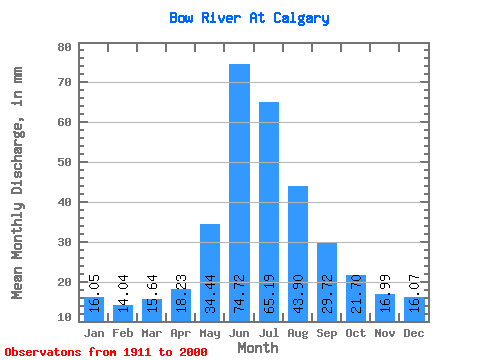
| Statistic | Jan | Feb | Mar | Apr | May | Jun | Jul | Aug | Sep | Oct | Nov | Dec | Annual |
|---|---|---|---|---|---|---|---|---|---|---|---|---|---|
| Mean | 15.97 | 14.09 | 15.56 | 18.13 | 34.26 | 74.34 | 64.84 | 43.67 | 29.57 | 21.59 | 16.90 | 15.98 | 363.43 |
| Standard Deviation | 5.09 | 4.70 | 4.94 | 5.46 | 10.92 | 25.39 | 23.00 | 12.55 | 8.03 | 5.12 | 3.73 | 4.88 | 65.07 |
| Min | 7.02 | 6.08 | 6.44 | 9.66 | 14.86 | 36.93 | 30.36 | 27.90 | 19.29 | 9.34 | 10.03 | 7.46 | 234.09 |
| Max | 26.68 | 24.52 | 27.90 | 35.28 | 70.53 | 155.65 | 148.89 | 80.75 | 63.32 | 36.12 | 26.94 | 27.43 | 588.20 |
| Coefficient of Variation | 0.32 | 0.33 | 0.32 | 0.30 | 0.32 | 0.34 | 0.35 | 0.29 | 0.27 | 0.24 | 0.22 | 0.30 | 0.18 |
 Return to R-Arctic Net Home Page