|
|
|||||||||||||||||
| Point ID: 2826 | Downloads | Plots | Site Data | Code: 05LJ016 |
|
|
|||||||||||||||||
| Download | |
|---|---|
| Site Descriptor Information | Site Time Series Data |
| Link to all available data | |
| View: | Time Series | All |
| Units: | mm |
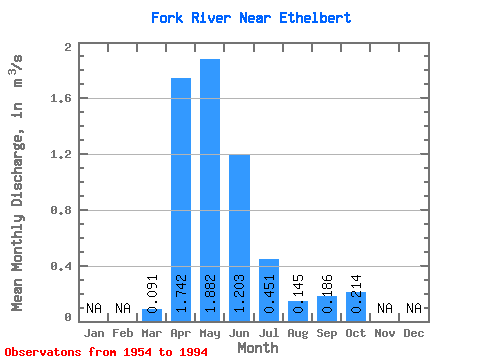
| Statistic | Jan | Feb | Mar | Apr | May | Jun | Jul | Aug | Sep | Oct | Nov | Dec | Annual |
|---|---|---|---|---|---|---|---|---|---|---|---|---|---|
| Mean | 0.09 | 1.74 | 1.88 | 1.20 | 0.45 | 0.14 | 0.19 | 0.21 | |||||
| Standard Deviation | 0.23 | 1.57 | 1.99 | 1.79 | 0.83 | 0.32 | 0.42 | 0.42 | |||||
| Min | 0.00 | 0.03 | 0.03 | 0.00 | 0.00 | 0.00 | 0.00 | 0.00 | |||||
| Max | 1.39 | 4.93 | 7.73 | 7.70 | 4.64 | 1.63 | 2.44 | 2.44 | |||||
| Coefficient of Variation | 2.53 | 0.90 | 1.06 | 1.49 | 1.84 | 2.20 | 2.29 | 1.95 |
 Return to R-Arctic Net Home Page