|
|
|||||||||||||||||
| Point ID: 2826 | Downloads | Plots | Site Data | Code: 05LJ016 |
|
|
|||||||||||||||||
| Download | |
|---|---|
| Site Descriptor Information | Site Time Series Data |
| Link to all available data | |
| View: | Time Series | All |
| Units: | m3/s |
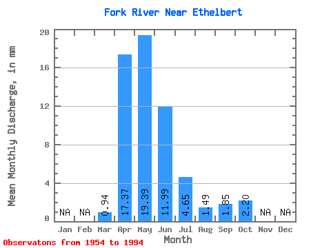
| Statistic | Jan | Feb | Mar | Apr | May | Jun | Jul | Aug | Sep | Oct | Nov | Dec | Annual |
|---|---|---|---|---|---|---|---|---|---|---|---|---|---|
| Mean | 0.94 | 17.36 | 19.38 | 12.00 | 4.64 | 1.49 | 1.85 | 2.21 | |||||
| Standard Deviation | 2.37 | 15.67 | 20.53 | 17.84 | 8.55 | 3.29 | 4.24 | 4.30 | |||||
| Min | 0.00 | 0.33 | 0.29 | 0.02 | 0.00 | 0.00 | 0.00 | 0.00 | |||||
| Max | 14.32 | 49.15 | 79.62 | 76.76 | 47.79 | 16.79 | 24.32 | 25.13 | |||||
| Coefficient of Variation | 2.53 | 0.90 | 1.06 | 1.49 | 1.84 | 2.20 | 2.29 | 1.95 |
 Return to R-Arctic Net Home Page