|
|
|||||||||||||||||
| Point ID: 2801 | Downloads | Plots | Site Data | Code: 05LE006 |
|
|
|||||||||||||||||
| Download | |
|---|---|
| Site Descriptor Information | Site Time Series Data |
| Link to all available data | |
| View: | Time Series | All |
| Units: | mm |
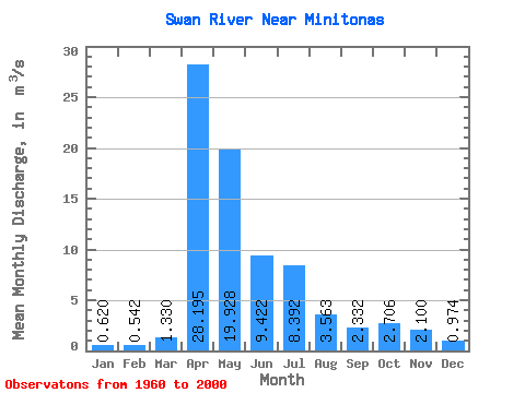
| Statistic | Jan | Feb | Mar | Apr | May | Jun | Jul | Aug | Sep | Oct | Nov | Dec | Annual |
|---|---|---|---|---|---|---|---|---|---|---|---|---|---|
| Mean | 0.62 | 0.54 | 1.33 | 28.20 | 19.93 | 9.42 | 8.39 | 3.56 | 2.33 | 2.71 | 2.10 | 0.97 | 6.59 |
| Standard Deviation | 0.35 | 0.29 | 2.25 | 21.27 | 19.70 | 9.02 | 9.59 | 5.26 | 2.54 | 2.02 | 2.28 | 0.61 | 3.99 |
| Min | 0.00 | 0.00 | 0.01 | 0.86 | 1.53 | 0.69 | 0.09 | 0.13 | 0.01 | 0.07 | 0.15 | 0.01 | 0.37 |
| Max | 1.19 | 1.03 | 13.60 | 79.00 | 69.10 | 35.00 | 40.60 | 23.80 | 11.50 | 7.11 | 13.20 | 2.83 | 18.14 |
| Coefficient of Variation | 0.56 | 0.53 | 1.69 | 0.75 | 0.99 | 0.96 | 1.14 | 1.48 | 1.09 | 0.74 | 1.09 | 0.62 | 0.60 |
 Return to R-Arctic Net Home Page