|
|
|||||||||||||||||
| Point ID: 2801 | Downloads | Plots | Site Data | Code: 05LE006 |
|
|
|||||||||||||||||
| Download | |
|---|---|
| Site Descriptor Information | Site Time Series Data |
| Link to all available data | |
| View: | Time Series | All |
| Units: | m3/s |
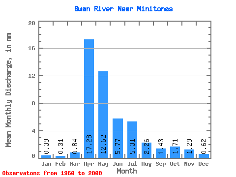
| Statistic | Jan | Feb | Mar | Apr | May | Jun | Jul | Aug | Sep | Oct | Nov | Dec | Annual |
|---|---|---|---|---|---|---|---|---|---|---|---|---|---|
| Mean | 0.39 | 0.31 | 0.84 | 17.28 | 12.62 | 5.77 | 5.31 | 2.26 | 1.43 | 1.71 | 1.29 | 0.62 | 49.20 |
| Standard Deviation | 0.22 | 0.17 | 1.43 | 13.03 | 12.47 | 5.53 | 6.07 | 3.33 | 1.55 | 1.28 | 1.40 | 0.39 | 29.78 |
| Min | 0.00 | 0.00 | 0.01 | 0.53 | 0.97 | 0.42 | 0.06 | 0.08 | 0.01 | 0.04 | 0.09 | 0.00 | 2.75 |
| Max | 0.75 | 0.59 | 8.61 | 48.41 | 43.75 | 21.45 | 25.70 | 15.07 | 7.05 | 4.50 | 8.09 | 1.79 | 135.36 |
| Coefficient of Variation | 0.56 | 0.53 | 1.69 | 0.75 | 0.99 | 0.96 | 1.14 | 1.48 | 1.09 | 0.74 | 1.09 | 0.62 | 0.60 |
 Return to R-Arctic Net Home Page