|
|
|||||||||||||||||
| Point ID: 2787 | Downloads | Plots | Site Data | Code: 04AC005 |
|
|
|||||||||||||||||
| Download | |
|---|---|
| Site Descriptor Information | Site Time Series Data |
| Link to all available data | |
| View: | Time Series | All |
| Units: | mm |
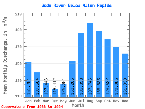
| Statistic | Jan | Feb | Mar | Apr | May | Jun | Jul | Aug | Sep | Oct | Nov | Dec | Annual |
|---|---|---|---|---|---|---|---|---|---|---|---|---|---|
| Mean | 151.78 | 139.58 | 127.45 | 119.41 | 126.08 | 153.29 | 185.83 | 197.75 | 188.82 | 178.62 | 170.09 | 161.93 | 159.46 |
| Standard Deviation | 49.73 | 40.89 | 32.45 | 26.34 | 25.89 | 41.31 | 68.26 | 78.03 | 72.26 | 65.62 | 59.80 | 57.49 | 41.77 |
| Min | 57.10 | 62.00 | 65.20 | 67.60 | 72.00 | 78.20 | 80.70 | 77.70 | 82.30 | 75.90 | 72.70 | 63.90 | 81.83 |
| Max | 287.00 | 244.00 | 205.00 | 179.00 | 184.00 | 276.00 | 404.00 | 410.00 | 387.00 | 375.00 | 339.00 | 320.00 | 259.00 |
| Coefficient of Variation | 0.33 | 0.29 | 0.26 | 0.22 | 0.20 | 0.27 | 0.37 | 0.40 | 0.38 | 0.37 | 0.35 | 0.35 | 0.26 |
 Return to R-Arctic Net Home Page