|
|
|||||||||||||||||
| Point ID: 2787 | Downloads | Plots | Site Data | Code: 04AC005 |
|
|
|||||||||||||||||
| Download | |
|---|---|
| Site Descriptor Information | Site Time Series Data |
| Link to all available data | |
| View: | Time Series | All |
| Units: | m3/s |
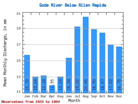
| Statistic | Jan | Feb | Mar | Apr | May | Jun | Jul | Aug | Sep | Oct | Nov | Dec | Annual |
|---|---|---|---|---|---|---|---|---|---|---|---|---|---|
| Mean | 15.69 | 13.15 | 13.18 | 11.95 | 13.04 | 15.34 | 19.21 | 20.45 | 18.90 | 18.47 | 17.02 | 16.74 | 194.31 |
| Standard Deviation | 5.14 | 3.85 | 3.35 | 2.64 | 2.68 | 4.13 | 7.06 | 8.07 | 7.23 | 6.79 | 5.99 | 5.94 | 50.90 |
| Min | 5.90 | 5.84 | 6.74 | 6.76 | 7.45 | 7.83 | 8.34 | 8.03 | 8.24 | 7.85 | 7.28 | 6.61 | 99.72 |
| Max | 29.68 | 22.99 | 21.20 | 17.91 | 19.02 | 27.62 | 41.77 | 42.39 | 38.73 | 38.77 | 33.93 | 33.09 | 315.60 |
| Coefficient of Variation | 0.33 | 0.29 | 0.26 | 0.22 | 0.20 | 0.27 | 0.37 | 0.40 | 0.38 | 0.37 | 0.35 | 0.35 | 0.26 |
 Return to R-Arctic Net Home Page