|
|
|||||||||||||||||
| Point ID: 2782 | Downloads | Plots | Site Data | Code: 10CD006 |
|
|
|||||||||||||||||
| Download | |
|---|---|
| Site Descriptor Information | Site Time Series Data |
| Link to all available data | |
| View: | Time Series | All |
| Units: | mm |
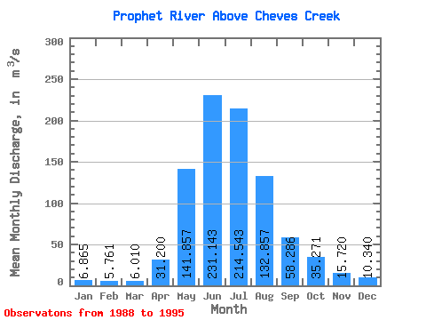
| Statistic | Jan | Feb | Mar | Apr | May | Jun | Jul | Aug | Sep | Oct | Nov | Dec | Annual |
|---|---|---|---|---|---|---|---|---|---|---|---|---|---|
| Mean | 6.87 | 5.76 | 6.01 | 31.20 | 141.86 | 231.14 | 214.54 | 132.86 | 58.29 | 35.27 | 15.72 | 10.34 | 74.22 |
| Standard Deviation | 2.00 | 1.56 | 3.00 | 9.90 | 77.99 | 62.46 | 73.48 | 97.02 | 21.31 | 12.60 | 5.84 | 3.44 | 16.15 |
| Min | 4.54 | 4.26 | 2.97 | 15.60 | 65.30 | 137.00 | 95.80 | 49.20 | 32.50 | 16.00 | 9.54 | 5.89 | 50.92 |
| Max | 9.62 | 8.62 | 11.90 | 45.90 | 286.00 | 317.00 | 283.00 | 274.00 | 94.60 | 51.60 | 24.40 | 15.40 | 95.23 |
| Coefficient of Variation | 0.29 | 0.27 | 0.50 | 0.32 | 0.55 | 0.27 | 0.34 | 0.73 | 0.37 | 0.36 | 0.37 | 0.33 | 0.22 |
 Return to R-Arctic Net Home Page