|
|
|||||||||||||||||
| Point ID: 2782 | Downloads | Plots | Site Data | Code: 10CD006 |
|
|
|||||||||||||||||
| Download | |
|---|---|
| Site Descriptor Information | Site Time Series Data |
| Link to all available data | |
| View: | Time Series | All |
| Units: | m3/s |
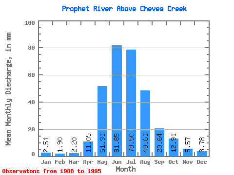
| Statistic | Jan | Feb | Mar | Apr | May | Jun | Jul | Aug | Sep | Oct | Nov | Dec | Annual |
|---|---|---|---|---|---|---|---|---|---|---|---|---|---|
| Mean | 2.51 | 1.92 | 2.20 | 11.05 | 51.90 | 81.85 | 78.49 | 48.60 | 20.64 | 12.90 | 5.57 | 3.78 | 319.98 |
| Standard Deviation | 0.73 | 0.52 | 1.10 | 3.50 | 28.53 | 22.12 | 26.88 | 35.49 | 7.55 | 4.61 | 2.07 | 1.26 | 69.62 |
| Min | 1.66 | 1.42 | 1.09 | 5.52 | 23.89 | 48.51 | 35.05 | 18.00 | 11.51 | 5.85 | 3.38 | 2.15 | 219.56 |
| Max | 3.52 | 2.87 | 4.35 | 16.25 | 104.63 | 112.25 | 103.53 | 100.24 | 33.50 | 18.88 | 8.64 | 5.63 | 410.56 |
| Coefficient of Variation | 0.29 | 0.27 | 0.50 | 0.32 | 0.55 | 0.27 | 0.34 | 0.73 | 0.37 | 0.36 | 0.37 | 0.33 | 0.22 |
 Return to R-Arctic Net Home Page