|
|
|||||||||||||||||
| Point ID: 2759 | Downloads | Plots | Site Data | Code: 10BB002 |
|
|
|||||||||||||||||
| Download | |
|---|---|
| Site Descriptor Information | Site Time Series Data |
| Link to all available data | |
| View: | Time Series | All |
| Units: | mm |
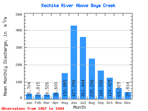
| Statistic | Jan | Feb | Mar | Apr | May | Jun | Jul | Aug | Sep | Oct | Nov | Dec | Annual |
|---|---|---|---|---|---|---|---|---|---|---|---|---|---|
| Mean | 30.70 | 26.82 | 26.53 | 36.60 | 150.88 | 427.30 | 361.44 | 235.30 | 166.04 | 124.42 | 63.93 | 39.81 | 140.66 |
| Standard Deviation | 5.62 | 4.69 | 4.52 | 7.80 | 52.43 | 86.72 | 82.44 | 44.66 | 37.50 | 34.76 | 12.62 | 6.77 | 14.82 |
| Min | 18.40 | 14.90 | 14.40 | 24.70 | 81.60 | 301.00 | 188.00 | 167.00 | 112.00 | 77.10 | 44.90 | 30.20 | 106.87 |
| Max | 42.20 | 36.60 | 35.20 | 54.80 | 300.00 | 624.00 | 488.00 | 345.00 | 252.00 | 205.00 | 92.10 | 61.30 | 170.87 |
| Coefficient of Variation | 0.18 | 0.17 | 0.17 | 0.21 | 0.35 | 0.20 | 0.23 | 0.19 | 0.23 | 0.28 | 0.20 | 0.17 | 0.10 |
 Return to R-Arctic Net Home Page