|
|
|||||||||||||||||
| Point ID: 2759 | Downloads | Plots | Site Data | Code: 10BB002 |
|
|
|||||||||||||||||
| Download | |
|---|---|
| Site Descriptor Information | Site Time Series Data |
| Link to all available data | |
| View: | Time Series | All |
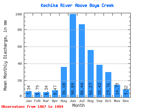
| Units: | m3/s |
| Statistic | Jan | Feb | Mar | Apr | May | Jun | Jul | Aug | Sep | Oct | Nov | Dec | Annual |
|---|---|---|---|---|---|---|---|---|---|---|---|---|---|
| Mean | 7.34 | 5.84 | 6.34 | 8.47 | 36.08 | 98.89 | 86.42 | 56.26 | 38.42 | 29.75 | 14.79 | 9.52 | 396.36 |
| Standard Deviation | 1.34 | 1.02 | 1.08 | 1.80 | 12.54 | 20.07 | 19.71 | 10.68 | 8.68 | 8.31 | 2.92 | 1.62 | 41.76 |
| Min | 4.40 | 3.25 | 3.44 | 5.72 | 19.51 | 69.66 | 44.95 | 39.93 | 25.92 | 18.43 | 10.39 | 7.22 | 301.13 |
| Max | 10.09 | 7.97 | 8.42 | 12.68 | 71.73 | 144.41 | 116.68 | 82.49 | 58.32 | 49.02 | 21.32 | 14.66 | 481.48 |
| Coefficient of Variation | 0.18 | 0.17 | 0.17 | 0.21 | 0.35 | 0.20 | 0.23 | 0.19 | 0.23 | 0.28 | 0.20 | 0.17 | 0.10 |
 Return to R-Arctic Net Home Page