|
|
|||||||||||||||||
| Point ID: 2757 | Downloads | Plots | Site Data | Code: 10BA001 |
|
|
|||||||||||||||||
| Download | |
|---|---|
| Site Descriptor Information | Site Time Series Data |
| Link to all available data | |
| View: | Time Series | All |
| Units: | mm |
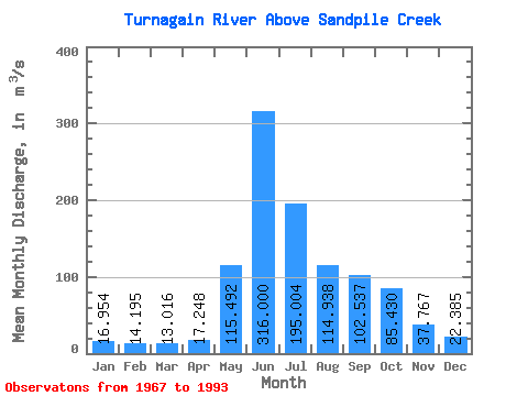
| Statistic | Jan | Feb | Mar | Apr | May | Jun | Jul | Aug | Sep | Oct | Nov | Dec | Annual |
|---|---|---|---|---|---|---|---|---|---|---|---|---|---|
| Mean | 16.95 | 14.20 | 13.02 | 17.25 | 115.49 | 316.00 | 195.00 | 114.94 | 102.54 | 85.43 | 37.77 | 22.39 | 87.45 |
| Standard Deviation | 4.33 | 3.18 | 2.89 | 4.06 | 56.42 | 67.25 | 58.27 | 33.53 | 30.54 | 32.80 | 12.03 | 6.29 | 10.30 |
| Min | 10.10 | 6.38 | 6.01 | 5.85 | 37.20 | 192.00 | 84.10 | 72.10 | 48.20 | 44.40 | 22.30 | 15.40 | 56.53 |
| Max | 27.70 | 19.90 | 18.20 | 25.10 | 245.00 | 444.00 | 332.00 | 188.00 | 165.00 | 194.00 | 68.60 | 45.60 | 101.98 |
| Coefficient of Variation | 0.26 | 0.22 | 0.22 | 0.23 | 0.49 | 0.21 | 0.30 | 0.29 | 0.30 | 0.38 | 0.32 | 0.28 | 0.12 |
 Return to R-Arctic Net Home Page