|
|
|||||||||||||||||
| Point ID: 2757 | Downloads | Plots | Site Data | Code: 10BA001 |
|
|
|||||||||||||||||
| Download | |
|---|---|
| Site Descriptor Information | Site Time Series Data |
| Link to all available data | |
| View: | Time Series | All |
| Units: | m3/s |
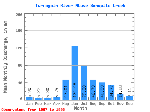
| Statistic | Jan | Feb | Mar | Apr | May | Jun | Jul | Aug | Sep | Oct | Nov | Dec | Annual |
|---|---|---|---|---|---|---|---|---|---|---|---|---|---|
| Mean | 6.90 | 5.26 | 5.30 | 6.79 | 47.00 | 124.48 | 79.36 | 46.78 | 40.39 | 34.77 | 14.88 | 9.11 | 419.42 |
| Standard Deviation | 1.76 | 1.18 | 1.18 | 1.60 | 22.96 | 26.49 | 23.72 | 13.65 | 12.03 | 13.35 | 4.74 | 2.56 | 49.43 |
| Min | 4.11 | 2.37 | 2.45 | 2.30 | 15.14 | 75.63 | 34.23 | 29.34 | 18.99 | 18.07 | 8.78 | 6.27 | 271.15 |
| Max | 11.27 | 7.38 | 7.41 | 9.89 | 99.71 | 174.90 | 135.12 | 76.51 | 65.00 | 78.96 | 27.02 | 18.56 | 489.15 |
| Coefficient of Variation | 0.26 | 0.22 | 0.22 | 0.23 | 0.49 | 0.21 | 0.30 | 0.29 | 0.30 | 0.38 | 0.32 | 0.28 | 0.12 |
 Return to R-Arctic Net Home Page