|
|
|||||||||||||||||
| Point ID: 2744 | Downloads | Plots | Site Data | Code: 09AA008 |
|
|
|||||||||||||||||
| Download | |
|---|---|
| Site Descriptor Information | Site Time Series Data |
| Link to all available data | |
| View: | Time Series | All |
| Units: | mm |
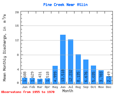
| Statistic | Jan | Feb | Mar | Apr | May | Jun | Jul | Aug | Sep | Oct | Nov | Dec | Annual |
|---|---|---|---|---|---|---|---|---|---|---|---|---|---|
| Mean | 1.69 | 1.63 | 1.43 | 1.52 | 5.00 | 13.52 | 12.23 | 8.13 | 6.68 | 5.04 | 3.78 | 2.15 | 5.15 |
| Standard Deviation | 0.53 | 0.49 | 0.36 | 0.38 | 1.85 | 4.44 | 2.65 | 2.29 | 2.63 | 2.01 | 1.04 | 0.78 | 1.09 |
| Min | 0.79 | 0.85 | 0.91 | 0.99 | 2.32 | 9.25 | 8.08 | 3.12 | 2.67 | 2.11 | 1.44 | 1.02 | 3.34 |
| Max | 2.41 | 2.46 | 1.99 | 2.33 | 9.57 | 27.20 | 18.20 | 12.50 | 11.80 | 9.26 | 5.23 | 3.76 | 6.56 |
| Coefficient of Variation | 0.31 | 0.30 | 0.25 | 0.25 | 0.37 | 0.33 | 0.22 | 0.28 | 0.39 | 0.40 | 0.28 | 0.36 | 0.21 |
 Return to R-Arctic Net Home Page