|
|
|||||||||||||||||
| Point ID: 2744 | Downloads | Plots | Site Data | Code: 09AA008 |
|
|
|||||||||||||||||
| Download | |
|---|---|
| Site Descriptor Information | Site Time Series Data |
| Link to all available data | |
| View: | Time Series | All |
| Units: | m3/s |
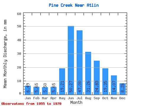
| Statistic | Jan | Feb | Mar | Apr | May | Jun | Jul | Aug | Sep | Oct | Nov | Dec | Annual |
|---|---|---|---|---|---|---|---|---|---|---|---|---|---|
| Mean | 6.49 | 5.70 | 5.50 | 5.64 | 19.20 | 50.27 | 47.00 | 31.26 | 24.83 | 19.34 | 14.07 | 8.26 | 233.37 |
| Standard Deviation | 2.02 | 1.70 | 1.39 | 1.39 | 7.13 | 16.53 | 10.16 | 8.78 | 9.79 | 7.71 | 3.87 | 2.98 | 49.46 |
| Min | 3.03 | 2.98 | 3.50 | 3.69 | 8.91 | 34.40 | 31.05 | 11.99 | 9.93 | 8.11 | 5.36 | 3.92 | 151.27 |
| Max | 9.26 | 8.61 | 7.65 | 8.66 | 36.77 | 101.15 | 69.93 | 48.03 | 43.88 | 35.58 | 19.45 | 14.45 | 297.26 |
| Coefficient of Variation | 0.31 | 0.30 | 0.25 | 0.25 | 0.37 | 0.33 | 0.22 | 0.28 | 0.39 | 0.40 | 0.28 | 0.36 | 0.21 |
 Return to R-Arctic Net Home Page