|
|
|||||||||||||||||
| Point ID: 2743 | Downloads | Plots | Site Data | Code: 09AA006 |
|
|
|||||||||||||||||
| Download | |
|---|---|
| Site Descriptor Information | Site Time Series Data |
| Link to all available data | |
| View: | Time Series | All |
| Units: | mm |
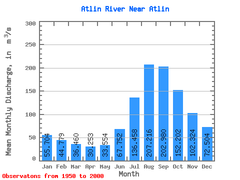
| Statistic | Jan | Feb | Mar | Apr | May | Jun | Jul | Aug | Sep | Oct | Nov | Dec | Annual |
|---|---|---|---|---|---|---|---|---|---|---|---|---|---|
| Mean | 55.70 | 44.78 | 36.46 | 30.25 | 33.55 | 67.75 | 136.46 | 207.22 | 202.98 | 152.20 | 102.32 | 72.50 | 95.45 |
| Standard Deviation | 8.73 | 6.96 | 5.75 | 4.89 | 6.97 | 17.38 | 28.18 | 36.00 | 35.71 | 28.72 | 17.45 | 11.90 | 14.48 |
| Min | 38.10 | 30.40 | 25.50 | 20.30 | 22.30 | 32.30 | 84.50 | 143.00 | 135.00 | 96.30 | 64.90 | 48.20 | 65.18 |
| Max | 71.30 | 58.30 | 54.80 | 47.70 | 50.30 | 117.00 | 202.00 | 279.00 | 286.00 | 205.00 | 136.00 | 94.80 | 124.65 |
| Coefficient of Variation | 0.16 | 0.15 | 0.16 | 0.16 | 0.21 | 0.26 | 0.21 | 0.17 | 0.18 | 0.19 | 0.17 | 0.16 | 0.15 |
 Return to R-Arctic Net Home Page