|
|
|||||||||||||||||
| Point ID: 2743 | Downloads | Plots | Site Data | Code: 09AA006 |
|
|
|||||||||||||||||
| Download | |
|---|---|
| Site Descriptor Information | Site Time Series Data |
| Link to all available data | |
| View: | Time Series | All |
| Units: | m3/s |
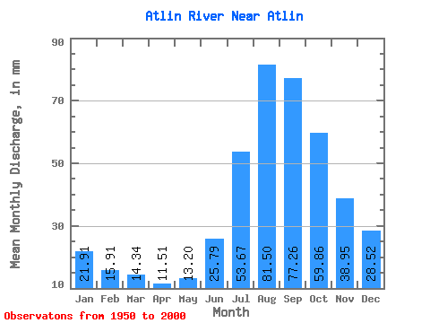
| Statistic | Jan | Feb | Mar | Apr | May | Jun | Jul | Aug | Sep | Oct | Nov | Dec | Annual |
|---|---|---|---|---|---|---|---|---|---|---|---|---|---|
| Mean | 21.91 | 16.04 | 14.34 | 11.52 | 13.20 | 25.79 | 53.66 | 81.49 | 77.26 | 59.85 | 38.95 | 28.51 | 442.37 |
| Standard Deviation | 3.44 | 2.49 | 2.26 | 1.86 | 2.74 | 6.62 | 11.08 | 14.16 | 13.59 | 11.29 | 6.64 | 4.68 | 67.10 |
| Min | 14.98 | 10.89 | 10.03 | 7.73 | 8.77 | 12.29 | 33.23 | 56.23 | 51.38 | 37.87 | 24.70 | 18.95 | 302.08 |
| Max | 28.04 | 20.89 | 21.55 | 18.16 | 19.78 | 44.53 | 79.44 | 109.72 | 108.86 | 80.61 | 51.76 | 37.28 | 577.67 |
| Coefficient of Variation | 0.16 | 0.15 | 0.16 | 0.16 | 0.21 | 0.26 | 0.21 | 0.17 | 0.18 | 0.19 | 0.17 | 0.16 | 0.15 |
 Return to R-Arctic Net Home Page