|
|
|||||||||||||||||
| Point ID: 260 | Downloads | Plots | Site Data | Code: 05BF008 |
|
|
|||||||||||||||||
| Download | |
|---|---|
| Site Descriptor Information | Site Time Series Data |
| Link to all available data | |
| View: | Time Series | All |
| Units: | mm |
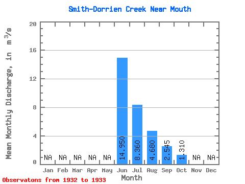
| Statistic | Jan | Feb | Mar | Apr | May | Jun | Jul | Aug | Sep | Oct | Nov | Dec | Annual |
|---|---|---|---|---|---|---|---|---|---|---|---|---|---|
| Mean | 14.95 | 8.36 | 4.68 | 2.54 | 1.31 | ||||||||
| Standard Deviation | 3.04 | 2.04 | 0.31 | 0.42 | 0.10 | ||||||||
| Min | 12.80 | 6.92 | 4.46 | 2.25 | 1.24 | ||||||||
| Max | 17.10 | 9.80 | 4.90 | 2.84 | 1.38 | ||||||||
| Coefficient of Variation | 0.20 | 0.24 | 0.07 | 0.16 | 0.08 |
 Return to R-Arctic Net Home Page