|
|
|||||||||||||||||
| Point ID: 260 | Downloads | Plots | Site Data | Code: 05BF008 |
|
|
|||||||||||||||||
| Download | |
|---|---|
| Site Descriptor Information | Site Time Series Data |
| Link to all available data | |
| View: | Time Series | All |
| Units: | m3/s |
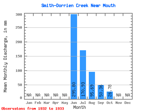
| Statistic | Jan | Feb | Mar | Apr | May | Jun | Jul | Aug | Sep | Oct | Nov | Dec | Annual |
|---|---|---|---|---|---|---|---|---|---|---|---|---|---|
| Mean | 295.81 | 170.90 | 95.67 | 50.36 | 26.78 | ||||||||
| Standard Deviation | 60.16 | 41.63 | 6.36 | 8.26 | 2.02 | ||||||||
| Min | 253.26 | 141.46 | 91.17 | 44.52 | 25.35 | ||||||||
| Max | 338.35 | 200.34 | 100.17 | 56.19 | 28.21 | ||||||||
| Coefficient of Variation | 0.20 | 0.24 | 0.07 | 0.16 | 0.08 |
 Return to R-Arctic Net Home Page