|
|
|||||||||||||||||
| Point ID: 243 | Downloads | Plots | Site Data | Code: 05BC008 |
|
|
|||||||||||||||||
| Download | |
|---|---|
| Site Descriptor Information | Site Time Series Data |
| Link to all available data | |
| View: | Time Series | All |
| Units: | mm |
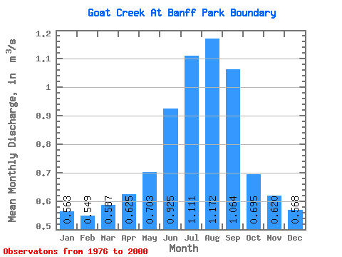
| Statistic | Jan | Feb | Mar | Apr | May | Jun | Jul | Aug | Sep | Oct | Nov | Dec | Annual |
|---|---|---|---|---|---|---|---|---|---|---|---|---|---|
| Mean | 0.56 | 0.55 | 0.59 | 0.62 | 0.70 | 0.93 | 1.11 | 1.17 | 1.06 | 0.69 | 0.62 | 0.57 | 0.77 |
| Standard Deviation | 0.32 | 0.33 | 0.33 | 0.32 | 0.32 | 0.36 | 0.69 | 0.57 | 0.73 | 0.33 | 0.34 | 0.32 | 0.26 |
| Min | 0.23 | 0.20 | 0.10 | 0.17 | 0.27 | 0.38 | 0.41 | 0.43 | 0.41 | 0.33 | 0.31 | 0.27 | 0.34 |
| Max | 1.22 | 1.18 | 1.29 | 1.29 | 1.47 | 1.74 | 3.59 | 2.29 | 3.55 | 1.49 | 1.31 | 1.28 | 1.42 |
| Coefficient of Variation | 0.57 | 0.60 | 0.56 | 0.52 | 0.45 | 0.39 | 0.62 | 0.49 | 0.69 | 0.48 | 0.54 | 0.56 | 0.34 |
 Return to R-Arctic Net Home Page