|
|
|||||||||||||||||
| Point ID: 243 | Downloads | Plots | Site Data | Code: 05BC008 |
|
|
|||||||||||||||||
| Download | |
|---|---|
| Site Descriptor Information | Site Time Series Data |
| Link to all available data | |
| View: | Time Series | All |
| Units: | m3/s |
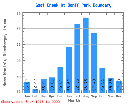
| Statistic | Jan | Feb | Mar | Apr | May | Jun | Jul | Aug | Sep | Oct | Nov | Dec | Annual |
|---|---|---|---|---|---|---|---|---|---|---|---|---|---|
| Mean | 36.85 | 32.76 | 38.41 | 39.63 | 46.04 | 58.60 | 72.76 | 76.76 | 67.44 | 45.49 | 39.31 | 37.21 | 590.48 |
| Standard Deviation | 21.16 | 19.57 | 21.38 | 20.52 | 20.79 | 22.93 | 45.23 | 37.66 | 46.43 | 21.68 | 21.25 | 20.94 | 202.85 |
| Min | 14.93 | 11.75 | 6.55 | 11.09 | 17.55 | 24.27 | 27.04 | 27.89 | 26.24 | 21.61 | 19.65 | 17.88 | 259.66 |
| Max | 79.88 | 70.40 | 84.47 | 81.75 | 96.25 | 110.27 | 235.06 | 149.94 | 224.98 | 97.56 | 83.02 | 83.81 | 1098.30 |
| Coefficient of Variation | 0.57 | 0.60 | 0.56 | 0.52 | 0.45 | 0.39 | 0.62 | 0.49 | 0.69 | 0.48 | 0.54 | 0.56 | 0.34 |
 Return to R-Arctic Net Home Page