|
|
|||||||||||||||||
| Point ID: 237 | Downloads | Plots | Site Data | Code: 05BB005 |
|
|
|||||||||||||||||
| Download | |
|---|---|
| Site Descriptor Information | Site Time Series Data |
| Link to all available data | |
| View: | Time Series | All |
| Units: | mm |
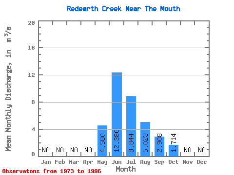
| Statistic | Jan | Feb | Mar | Apr | May | Jun | Jul | Aug | Sep | Oct | Nov | Dec | Annual |
|---|---|---|---|---|---|---|---|---|---|---|---|---|---|
| Mean | 4.58 | 12.38 | 8.84 | 5.02 | 2.91 | 1.71 | |||||||
| Standard Deviation | 2.38 | 2.92 | 3.09 | 1.44 | 0.87 | 0.37 | |||||||
| Min | 1.43 | 7.38 | 4.85 | 3.27 | 1.84 | 1.23 | |||||||
| Max | 11.60 | 18.10 | 14.90 | 8.41 | 5.83 | 2.62 | |||||||
| Coefficient of Variation | 0.52 | 0.24 | 0.35 | 0.29 | 0.30 | 0.22 |
 Return to R-Arctic Net Home Page