|
|
|||||||||||||||||
| Point ID: 237 | Downloads | Plots | Site Data | Code: 05BB005 |
|
|
|||||||||||||||||
| Download | |
|---|---|
| Site Descriptor Information | Site Time Series Data |
| Link to all available data | |
| View: | Time Series | All |
| Units: | m3/s |
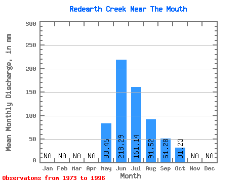
| Statistic | Jan | Feb | Mar | Apr | May | Jun | Jul | Aug | Sep | Oct | Nov | Dec | Annual |
|---|---|---|---|---|---|---|---|---|---|---|---|---|---|
| Mean | 83.44 | 218.28 | 161.12 | 91.52 | 51.27 | 31.22 | |||||||
| Standard Deviation | 43.35 | 51.56 | 56.30 | 26.15 | 15.33 | 6.74 | |||||||
| Min | 26.05 | 130.13 | 88.36 | 59.57 | 32.44 | 22.41 | |||||||
| Max | 211.32 | 319.15 | 271.44 | 153.21 | 102.80 | 47.73 | |||||||
| Coefficient of Variation | 0.52 | 0.24 | 0.35 | 0.29 | 0.30 | 0.22 |
 Return to R-Arctic Net Home Page