|
|
|||||||||||||||||
| Point ID: 22 | Downloads | Plots | Site Data | Code: 05AA027 |
|
|
|||||||||||||||||
| Download | |
|---|---|
| Site Descriptor Information | Site Time Series Data |
| Link to all available data | |
| View: | Time Series | All |
| Units: | mm |
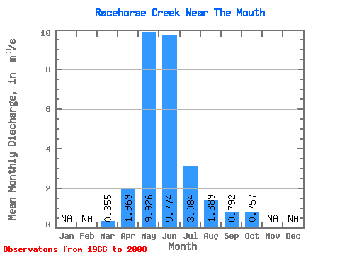
| Statistic | Jan | Feb | Mar | Apr | May | Jun | Jul | Aug | Sep | Oct | Nov | Dec | Annual |
|---|---|---|---|---|---|---|---|---|---|---|---|---|---|
| Mean | 0.35 | 1.97 | 9.93 | 9.77 | 3.08 | 1.39 | 0.79 | 0.76 | |||||
| Standard Deviation | 0.15 | 1.19 | 3.77 | 5.24 | 1.84 | 1.75 | 0.43 | 0.40 | |||||
| Min | 0.19 | 0.42 | 3.59 | 2.16 | 0.71 | 0.53 | 0.39 | 0.34 | |||||
| Max | 0.80 | 4.86 | 18.50 | 22.20 | 8.92 | 10.90 | 2.39 | 1.76 | |||||
| Coefficient of Variation | 0.42 | 0.60 | 0.38 | 0.54 | 0.60 | 1.26 | 0.54 | 0.53 |
 Return to R-Arctic Net Home Page