|
|
|||||||||||||||||
| Point ID: 22 | Downloads | Plots | Site Data | Code: 05AA027 |
|
|
|||||||||||||||||
| Download | |
|---|---|
| Site Descriptor Information | Site Time Series Data |
| Link to all available data | |
| View: | Time Series | All |
| Units: | m3/s |
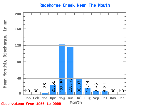
| Statistic | Jan | Feb | Mar | Apr | May | Jun | Jul | Aug | Sep | Oct | Nov | Dec | Annual |
|---|---|---|---|---|---|---|---|---|---|---|---|---|---|
| Mean | 4.38 | 23.52 | 122.50 | 116.75 | 38.05 | 17.14 | 9.46 | 9.35 | |||||
| Standard Deviation | 1.86 | 14.17 | 46.51 | 62.54 | 22.73 | 21.61 | 5.12 | 4.93 | |||||
| Min | 2.38 | 5.02 | 44.30 | 25.80 | 8.71 | 6.58 | 4.68 | 4.26 | |||||
| Max | 9.87 | 58.05 | 228.31 | 265.17 | 110.08 | 134.52 | 28.55 | 21.72 | |||||
| Coefficient of Variation | 0.42 | 0.60 | 0.38 | 0.54 | 0.60 | 1.26 | 0.54 | 0.53 |
 Return to R-Arctic Net Home Page