|
|
|||||||||||||||||
| Point ID: 210 | Downloads | Plots | Site Data | Code: 05AH041 |
|
|
|||||||||||||||||
| Download | |
|---|---|
| Site Descriptor Information | Site Time Series Data |
| Link to all available data | |
| View: | Time Series | All |
| Units: | mm |
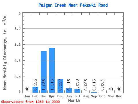
| Statistic | Jan | Feb | Mar | Apr | May | Jun | Jul | Aug | Sep | Oct | Nov | Dec | Annual |
|---|---|---|---|---|---|---|---|---|---|---|---|---|---|
| Mean | 0.16 | 1.04 | 1.12 | 0.34 | 0.12 | 0.10 | 0.00 | 0.01 | 0.00 | ||||
| Standard Deviation | 0.29 | 1.26 | 1.61 | 0.66 | 0.25 | 0.35 | 0.01 | 0.09 | 0.02 | ||||
| Min | 0.00 | 0.00 | 0.00 | 0.00 | 0.00 | 0.00 | 0.00 | 0.00 | 0.00 | ||||
| Max | 1.01 | 4.82 | 8.32 | 2.92 | 1.22 | 2.01 | 0.08 | 0.60 | 0.11 | ||||
| Coefficient of Variation | 1.87 | 1.21 | 1.44 | 1.97 | 2.18 | 3.50 | 4.91 | 6.07 | 4.88 |
 Return to R-Arctic Net Home Page