|
|
|||||||||||||||||
| Point ID: 210 | Downloads | Plots | Site Data | Code: 05AH041 |
|
|
|||||||||||||||||
| Download | |
|---|---|
| Site Descriptor Information | Site Time Series Data |
| Link to all available data | |
| View: | Time Series | All |
| Units: | m3/s |
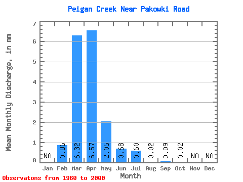
| Statistic | Jan | Feb | Mar | Apr | May | Jun | Jul | Aug | Sep | Oct | Nov | Dec | Annual |
|---|---|---|---|---|---|---|---|---|---|---|---|---|---|
| Mean | 0.86 | 6.32 | 6.57 | 2.05 | 0.68 | 0.60 | 0.02 | 0.09 | 0.02 | ||||
| Standard Deviation | 1.62 | 7.65 | 9.49 | 4.03 | 1.48 | 2.10 | 0.08 | 0.55 | 0.11 | ||||
| Min | 0.00 | 0.00 | 0.00 | 0.00 | 0.00 | 0.00 | 0.00 | 0.00 | 0.00 | ||||
| Max | 5.60 | 29.34 | 49.01 | 17.77 | 7.19 | 12.23 | 0.49 | 3.51 | 0.68 | ||||
| Coefficient of Variation | 1.87 | 1.21 | 1.44 | 1.97 | 2.18 | 3.50 | 4.91 | 6.07 | 4.88 |
 Return to R-Arctic Net Home Page