|
|
|||||||||||||||||
| Point ID: 21 | Downloads | Plots | Site Data | Code: 05AA026 |
|
|
|||||||||||||||||
| Download | |
|---|---|
| Site Descriptor Information | Site Time Series Data |
| Link to all available data | |
| View: | Time Series | All |
| Units: | mm |
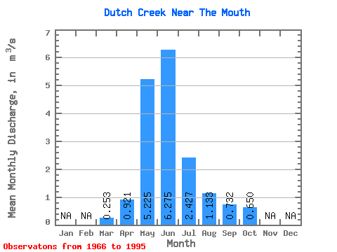
| Statistic | Jan | Feb | Mar | Apr | May | Jun | Jul | Aug | Sep | Oct | Nov | Dec | Annual |
|---|---|---|---|---|---|---|---|---|---|---|---|---|---|
| Mean | 0.25 | 0.92 | 5.22 | 6.28 | 2.43 | 1.13 | 0.73 | 0.65 | |||||
| Standard Deviation | 0.17 | 0.60 | 2.18 | 3.24 | 1.25 | 0.73 | 0.30 | 0.28 | |||||
| Min | 0.11 | 0.17 | 1.83 | 1.81 | 0.71 | 0.50 | 0.35 | 0.33 | |||||
| Max | 0.56 | 1.96 | 10.10 | 13.30 | 6.18 | 4.33 | 1.62 | 1.51 | |||||
| Coefficient of Variation | 0.66 | 0.65 | 0.42 | 0.52 | 0.51 | 0.65 | 0.42 | 0.44 |
 Return to R-Arctic Net Home Page