|
|
|||||||||||||||||
| Point ID: 21 | Downloads | Plots | Site Data | Code: 05AA026 |
|
|
|||||||||||||||||
| Download | |
|---|---|
| Site Descriptor Information | Site Time Series Data |
| Link to all available data | |
| View: | Time Series | All |
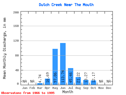
| Units: | m3/s |
| Statistic | Jan | Feb | Mar | Apr | May | Jun | Jul | Aug | Sep | Oct | Nov | Dec | Annual |
|---|---|---|---|---|---|---|---|---|---|---|---|---|---|
| Mean | 4.74 | 16.70 | 97.85 | 113.73 | 45.45 | 21.23 | 13.27 | 12.17 | |||||
| Standard Deviation | 3.13 | 10.80 | 40.88 | 58.75 | 23.31 | 13.69 | 5.52 | 5.33 | |||||
| Min | 2.13 | 3.12 | 34.27 | 32.81 | 13.28 | 9.36 | 6.43 | 6.18 | |||||
| Max | 10.54 | 35.53 | 189.15 | 241.07 | 115.73 | 81.09 | 29.36 | 28.28 | |||||
| Coefficient of Variation | 0.66 | 0.65 | 0.42 | 0.52 | 0.51 | 0.65 | 0.42 | 0.44 |
 Return to R-Arctic Net Home Page