|
|
|||||||||||||||||
| Point ID: 201 | Downloads | Plots | Site Data | Code: 05AH012 |
|
|
|||||||||||||||||
| Download | |
|---|---|
| Site Descriptor Information | Site Time Series Data |
| Link to all available data | |
| View: | Time Series | All |
| Units: | mm |
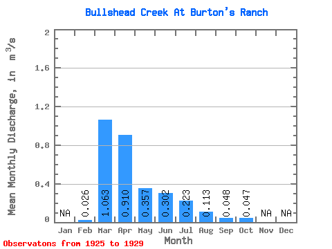
| Statistic | Jan | Feb | Mar | Apr | May | Jun | Jul | Aug | Sep | Oct | Nov | Dec | Annual |
|---|---|---|---|---|---|---|---|---|---|---|---|---|---|
| Mean | 0.03 | 1.06 | 0.91 | 0.36 | 0.30 | 0.22 | 0.11 | 0.05 | 0.05 | ||||
| Standard Deviation | 0.03 | 0.92 | 1.32 | 0.72 | 0.49 | 0.28 | 0.23 | 0.06 | 0.04 | ||||
| Min | 0.00 | 0.26 | 0.04 | 0.00 | 0.00 | 0.00 | 0.00 | 0.01 | 0.01 | ||||
| Max | 0.05 | 2.44 | 3.16 | 1.65 | 1.18 | 0.55 | 0.52 | 0.14 | 0.10 | ||||
| Coefficient of Variation | 1.25 | 0.86 | 1.45 | 2.03 | 1.64 | 1.25 | 2.02 | 1.16 | 0.75 |
 Return to R-Arctic Net Home Page