|
|
|||||||||||||||||
| Point ID: 201 | Downloads | Plots | Site Data | Code: 05AH012 |
|
|
|||||||||||||||||
| Download | |
|---|---|
| Site Descriptor Information | Site Time Series Data |
| Link to all available data | |
| View: | Time Series | All |
| Units: | m3/s |
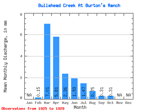
| Statistic | Jan | Feb | Mar | Apr | May | Jun | Jul | Aug | Sep | Oct | Nov | Dec | Annual |
|---|---|---|---|---|---|---|---|---|---|---|---|---|---|
| Mean | 0.15 | 6.92 | 5.74 | 2.33 | 1.91 | 1.45 | 0.73 | 0.30 | 0.31 | ||||
| Standard Deviation | 0.19 | 5.98 | 8.34 | 4.72 | 3.12 | 1.82 | 1.48 | 0.35 | 0.23 | ||||
| Min | 0.02 | 1.68 | 0.22 | 0.00 | 0.01 | 0.00 | 0.03 | 0.08 | 0.09 | ||||
| Max | 0.28 | 15.90 | 19.93 | 10.75 | 7.44 | 3.60 | 3.39 | 0.89 | 0.66 | ||||
| Coefficient of Variation | 1.25 | 0.86 | 1.45 | 2.03 | 1.64 | 1.25 | 2.02 | 1.16 | 0.75 |
 Return to R-Arctic Net Home Page